Last June at our mid-term conference we presented preliminary results from our research on Geovisualization methods for Historical GIS in Canada. That presentation along with a number of the others presented that day are available on this website, via the program document with embedded links AVAILABLE HERE (Scroll down to Whitepaper update: HGIS Geovisualization (Byron Moldofsky)). Since that time we have been working on revisions to the paper reviewing that research – and we also decided to change the titling of it from “White paper” to “Working paper” – reflecting the exploratory character of some of the research and the speculative nature of its results. The full “Working paper” is now available AT THIS LINK.
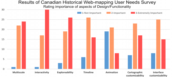
The paper may appear discouragingly long, but please do not be put off – about two thirds of the text is a reproduction of the online questionnaire we administered (Appendix 3: Canadian Historical Web-mapping User Needs Survey) and detailed reporting of some of the results of that survey (Part 4. Results of Canadian Historical Web-mapping User Needs Survey.) Many of you went online to take this survey – so you may be interested in what your peers have had to say, in the aggregate (see chart above, for example), and in selected comments. Thank you again for sharing your experiences and thoughts.
These “Results…” are the main addition to what was presented last June, along with a more developed “Part 5: Next steps: Developing principles of practice and for Canadian HGIS web-mapping activities, and plan to implement these in our Partnership development pilot website.” (pp. 45-48.) In this section we make the following proposals for principles of practice in developing our project’s collaborative web-mapping resources, which I would like to highlight here:
(Proposed) Principles of practice for Canadian HGIS Partnership web-mapping activities
- Support long-term sustainability and sharing of data and mapping
- Support of visualization for both presentation purposes and data exploration and analysis
- Support transparency of the web-mapping process, through good meta-data and documentation
- Support of multiple platforms, both technical (OS, browsers) and mapping (including proprietary and FOSS4G technologies)
- Working collaboratively to avoid duplication of effort and competition among current collaborators and potential partners
These principles are my interpretation of the responses to the User Needs Survey, and the discussion among the project members at meetings including the mid-term meeting last June. I would very much like to gather reaction from potential users and collaborators – so you are invited to respond by email or in the Comments section below this post.
Principles, however, are not of much use without a plan to implement them. The working paper proposes a three-pronged approach to supporting project HGIS web-mapping goals:
(Proposed) CHGIS Partnership development web-mapping pilot website activities
- Analytical evaluation framework: A set of questions to consider and evaluate in deciding on historical webmapping approach and technology
- Historical web-mapping technology profiles: Standardized descriptive comparison of technologies, incorporating “reviews”
- Comparative examples of web-mapping approaches: Examples of historical web-mapping projects using the same data and citing the same goals but using contrasting technologies
These three approaches are laid out in some detail in the concluding section of the working paper (Part 5, pp. 45-48), with tangible results proposed for each. If you have time, please take a look at this final section which outlines these pilot project activities, and suggests sample data sets, and let me know if you have any concerns or suggestions, either in the Comments section below, on the email listserv discussion thread or by personal email.
As we all know, such activities can consume large amounts of time and resources. We have reached consensus that the priority on the web-mapping side should be 3. Comparative examples of web-mapping approaches, while not completely neglecting the other two activities. Over the remaining months of the project we will work to create sample projects online for several of the data sets suggested within the paper. We have already started on these, and enlisted some of our partners and collaborators for data and technical assistance. We will try to provide one or two progress reports via these News and Notes posts, as soon as we have some neat web-mapping to show you!
This post is also available in: French