Guest post by S. Max Edelson, University of Virginia
This semester, I’m leading a group of University of Virginia undergraduates in a collaborative, project-based digital humanities course to put the Murray Map of Canada online in a dynamic digital exhibition. Taught as a selective Pavilion Seminar, this “Digital Practicum in Map History” is a hands-on experience that combines traditional reading, writing, and discussion with a workshop in digital humanities development. It involves an interdisciplinary focus on the history of cartography, visual design, digital humanities, public history, and the global history of empire.
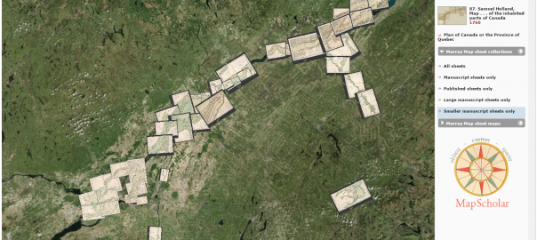
As librarians scan the contents of their map archives, preserving fragile artifacts by creating high-resolution images, new tools are being developed to present these vital historic objects to a broad public audience. One of those tools is MapScholar, a distributed, browser-based visualization authoring tool purposed-built for illustrating scholarship in the history of cartography. With support from the ACLS and the NEH, research scientist Bill Ferster and I built MapScholar at University of Virginia’s SHANTI (Sciences, Humanities, and Arts Network of Technological Initiatives). My primary goal was to build a dynamic platform to display some 300 maps that are the subject of my forthcoming book, The New Map of Empire: How Britain Imagined America before Independence (Harvard University Press, 2017). Among the many maps I examined for this research, I was intrigued by the Murray Map collection at the William H. Clements Library at the University of Michigan. This huge manuscript collection–copies of which are also held by the British Library and the Library and Archives of Canada–seemed an idea source to mount and view online, bringing all of its disparate pieces together through georeferencing to fully appreciate the scope and ambition of this eighteenth-century surveying and mapping project.
When British forces occupied New France in 1760, the territory’s military governor, General James Murray, initiated a comprehensive survey of what would become, after the formal cession in 1763, the British colony of Quebec. The impulse to map Quebec came from military rather than administrative designs. Murray expected the province to be handed back to France after the peace had been negotiated, and he wanted to gather strategic intelligence that might be useful in support of a future invasion. As Murray explained to William Pitt in 1762, with this survey in hand to reveal the intricate passages along the waterways of the St. Lawrence River valley, Britain “never again can be at a loss how to attack and conquer this country in one campaign.” Murray dispatched eight army engineers to lead surveys along different sections of the river. The composite map they produced contained seventy-four separately mapped sections that, when joined together, formed an interconnected image forty-five feet long and thirty-six feet tall. Representing space at the scale of two thousand feet to one inch, these maps were among the highest resolution topographic maps produced by eighteenth-century surveyors anywhere. The Murray maps’ design as a strategic profile of the province was made clear by the addition of demographic summaries that enumerated how many men capable of bearing arms lived in each district.
Map curators Brian Dunnigan and Mary Pedley at The William L. Clements Library at the University of Michigan provided high-resolution scans of the Murray Map and have met with the class via video conference to help us develop it. As students georeference maps, design dynamic visualizations, record object metadata, manage distributed web resources, and write essays and annotations that provide context and interpretation, they will gain first-hand experience in digital humanities work.
We are beginning to georeference the collection now, and I will provide updates about our progress in a future blog post.
S. Max Edelson is an Associate Professor at the University of Virginia in the Corcoran Department of History.